Burdekin Shire, an area of 5053 sq km, is generally 90 km south-east of Townsville. Its administrative centre is Ayr, and it was the Ayr local government division (1888-1903) and thence Ayr Shire until renamed in 1976.
The shire was named after the Burdekin River which flows northwards from the Leichhardt Range through Dalberg and Clare to the Lower Burdekin delta, passing between Ayr and Home Hill before entering the Pacific. The river was named by the explorer, Ludwig Leichhardt, in 1849, as a compliment to Thomas Burdekin, one of the sponsors of his expedition. Leichhardt charted the river west of the range, and it was some years before it was known that a river mouth near Ayr, the Wickham, was in fact the Burdekin.
SUGAR INDUSTRY
Shortly after pastoral runs were taken up in the Lower Burdekin in the early 1860s the town of Wickham was established on Rita Island near the river mouth. It was swept away by the Burdekin in one of its periodic floods. The Jarvisfield and Inkerman pastoral runs came under land selection in the early 1880s, and the delta land was quickly occupied for sugar growing. Brandon and Ayr townships were established in 1882, and numerous sugar mills were constructed. Most early mills failed after a few seasons but the Kalamia mill (1884) near Ayr and the Pioneer (1884) near Brandon became the dominant mills. Annual dry spells and periodic drought held back the sugar industry until John Drysdale, an engineer, used Abyssinian spears (perforated tubes with filters to exclude sand and gravel) to extract water from the shallow water table beneath the delta. Wind pumps and electric pumps powered from local electricity utilities drew the water to the farm distribution channels. Burdekin flood waters replenished the water table.
The Inkerman land repurchase led to more sugar farm selections, the town of Home Hill and the Inkerman mill (1914); and a similar repurchase on the Haughton River led to the town of Giru and the Invicta Mill (1921) in the north of the shire.
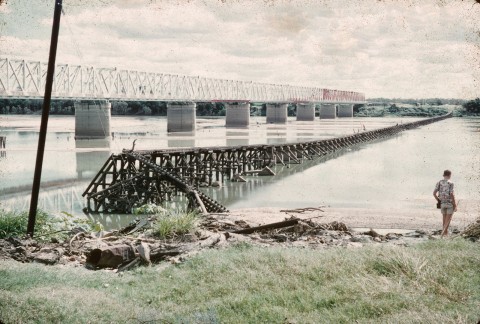
A railway line was opened from Townsville to Ayr (1901), a rail bridge crossed the Burdekin River to Home Hill in 1913, and a bridge for road traffic was built in 1930. Both were low level, often damaged, and were replaced by a dual traffic high level bridge (the Silver Link) in 1957.
IRRIGATION
Harnessing the Burdekin floods had been proposed as early as 1889, envisaging a dam at the gorge section of the river falls in the Leichhardt Range. A weir at the gorge was completed in 1953 for soldier settlement farms along the Burdekin Valley at Dalbeg, Millaroo and Clare. The farms optimistically concentrated on tobacco, which suffered from disease, storm damage and substandard leaf quality. They diversified into sugar, maize, vegetables and rice. Seed beans became a specialty.
The giant Burdekin Falls dam was begun in 1984 and water began filling it in 1987. Named Lake Dalrymple, the storage backs up a major tributary, the Belyando River. The storage ensures an even supply of irrigation water to the Lower Burdekin delta, both for crops and for maintenance of the water table. Sugar plantation lands were expanded, but at some environmental cost: much of the prolific bird life and brolga breeding areas left intact after eighty or more years of cropping were lost, and lagoons drained.
In common with many inland northern towns lacking the cooling effect of the coast, Ayr chose Alva Beach as its watering place. The Alva Beach life saving club was established in 1926 as residents day-tripped or camped at the coast. Several of the streams through the delta provide ideal fishing conditions.
Sugar is the dominant industry in the shire, supplying four mills. In 1993, 5.43 million tonnes were crushed, sourced from 43,268 ha of plantations. Numerous other cereal, fruit and vegetable crops were grown on 56,000 ha. Beyond the irrigation areas nearly 80,000 beef cattle were grazed.
The Burdekin Shire opened its first cyclone shelter, a category five-rated shelter at the Ayr Showgrounds on the Bruce Highway, in 2014.
Burdekin Shire's census populations have been:
| Census Date | Population |
|---|---|
| 1911 | 3279 |
| 1921 | 6254 |
| 1933 | 12,073 |
| 1961 | 16,758 |
| 1981 | 18,477 |
| 2001 | 18,486 |
| 2006 | 17,020 |
| 2011 | 17,364 |
Roy Connolly, John Drysdale and the Burdekin, Sydney, U. Smith, 1964
E.M. Driscoll, The irrigation settlements of the Lower Burdekin, Liverpool, Department of Geography, University of Liverpool, 1970
David Hooper, Australia's mightiest dam, Townsville, North Queensland Paper, 1979
John Kerr, Black snow and liquid gold: a history of the Burdekin Shire,Ayr, Council of the Shire of Burdekin, 1994
Ayr, Brandon, Dry Tropics, Giru, Home Hill, Inkerman and Jarvisfield entries