Tamborine is a village and rural/residential district midway between Beenleigh and Beaudesert. The village is at the intersection of the Beaudesert-Beenleigh Road and Tamborine Mountain Road, about two km south of the Albert River. Several of the river's tributary creeks flow through Tamborine.
The village was named after a pastoral run in the area; the name is thought to derive from an Aboriginal expression meaning wild lime or yam. An early European settler was Thomas Plunkett who selected land on the Albert River in the early 1870s and opened a store and post office (1874). Plunkett helped to get a school opened in St Mary's Catholic chapel in 1874, and later donated land in Plunkett Road (north of the Albert River) for a Catholic cemetery when the one near the chapel was found to be flood prone. The Tamborine chapel was the centre of the local parish until the connection of the railway in 1884 to Beaudesert. The Tambourine Hotel opened in 1882 and continued until the 1930s. (Note the spelling, 'Tambourine', applicable until 1939.)
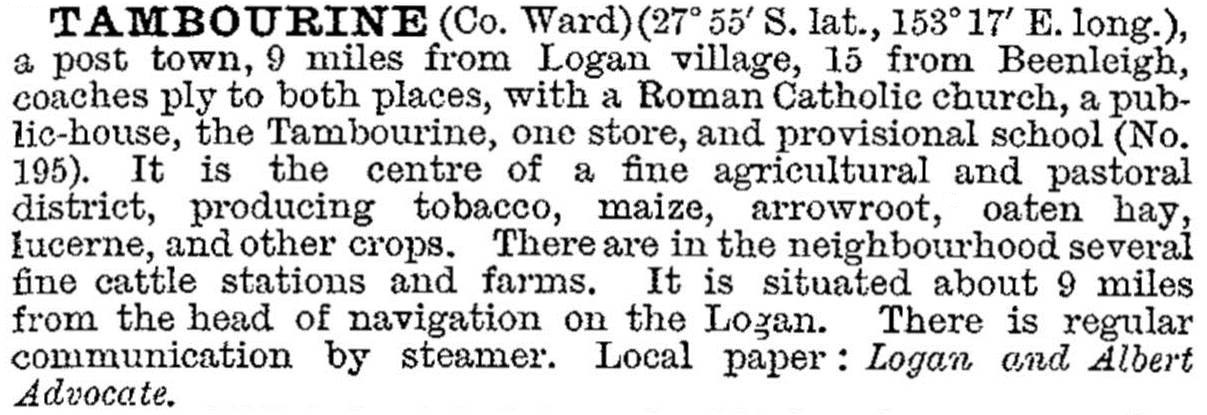
Tambourine was described in the 1903 Australian handbook:
The village was the administrative centre of the Tambourine local government division (1893) and shire (1903). It was on the railway line from Logan Village to Canungra (1915-55), which carried dairy produce and timber from Lahey's timber mill at Canungra, itself served by a tramway into the Lamington Range. The shire's area included Beechmont, Tamborine Mountain and Canungra. In 1933 the shire council supported Romeo Lahey's initiative for the creation of the Lamington National Park. Renamed Tamborine Shire in 1939, it was amalgamated with Beaudesert Shire in 1949.
Tamborine Shire was described in the 1946 Australian Blue Book:

Apart from having the shire offices, the village had only a store, a garage, the church and the school. The railway closed in 1955 and the school in 1970.
Today's Tamborine can be reached from Waterford by crossing the Albert River at Plunkett Bridge. The first buildings to be seen are the hall, the old Tamborine school building and a library in the Old School Reserve. At the cross roads, there are St Mary's Catholic Church, a recreation reserve, shops and a post office.
Tamborine district north of the Albert River is in Logan City, and south of the river (including the village) is in the Scenic Rim Regional Council.
Census populations have been:
| area | Census Date | Population |
|---|---|---|
| Tamborine and Tamborine Shire | 1911 | 1188 |
| 1933 | 2673 | |
| 1947 | 2596 | |
| Tamborine and district | 2006 | 3176 |
| 2011 | 3464 |
Beechmont, Canungra and Tamborine Mountain entries


