Buderim, named after Buderim Mountain, is a large suburb with a semi-rural hinterland, a few kilometres inland from Mooloolaba and 90 km north of central Brisbane. It is thought that the name derives from an Aboriginal word meaning 'honeysuckle' (the Banksia collina) or 'red soil'. If the former is the actual source of the name, it is erroneous to the extent that the Banksia is a coastal tree, whereas Buderim is in rainforest - it is possible that when explorer Tom Petrie queried his party of Aborigines on sighting Mount Buderim in 1862, they understood him to be asking instead about trees in the foreground.
Although called a mountain, the Buderim formation has an elevation of under 200m and is more a rising plateau which extends for about 7 km. It has red soil, impregnated with iron oxide.
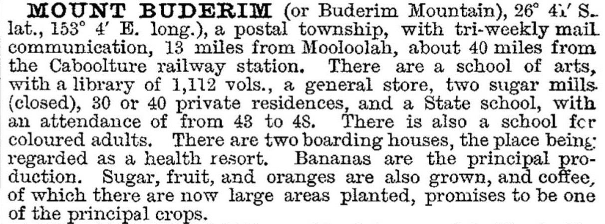
A timber miller, William Pettigrew, took up a timber lease in the area in 1864, two years after commissioning Petrie's exploration. The logs were hauled to Pettigrew's mill at Maroochydore. A township was surveyed in 1869 and a European resident, John Burnett, opened a store. His residence (c1882) is the heritage-registered Pioneer Cottage in Ballinger Crescent. In the 1870s sugar growing began at Buderim, and the first of two mills was opened in 1876. The mills failed, however, and cane was subsequently transported to Nambour for milling. Coffee, bananas and citrus were also grown at Buderim, continuing for some years, as the 1903 description of the town in the Australian handbook indicated:
The marketing of primary produce was helped by the opening in 1914 of a tramway from Buderim to Palmwoods (on the North Coast railway line). The tramway stimulated economic development generally, and played a significant social role, transporting residents to and from the railway. It also carried travellers and visitors up to what was becoming an elevated health resort: there were four boarding houses in Buderim according to Pugh's Queensland directory in 1925 (but no hotel until 1986 because of the influence of Methodists and Quakers). The tramway closed in 1935, although restoration of part of the track began in 2005, and remnants of the track and its foundations are listed on the Queensland heritage register.
Buderim became famous for ginger. As a commercial venture, ginger growing started there in 1916, and the loss of Asian imports to Australia in World War II spurred on improvements in quality and the quantity grown. Buderim's first processing factory opened in 1942. Sluggish performance led to export initiatives, and in 1979 processing was moved to Yandina. Tourist centres were opened at both Buderim and Yandina, but the Buderim facility has closed.
Until the mid-1960s Buderim was a country town with fewer than 1000 people. Its elevated position and proximity to the Sunshine Coast made it an attractive target for subdividers. Alfred Grand's Bellevue estate was the first of several, cutting up farms for house blocks, often for retirees.
Buderim's suburban boundary adjoins Mooloolaba and extends westwards for over 6 km. It has several retirement villages, an aged persons' facilities and the Sunshine Coast Private Hospital. Most of the eastern (seaward) part of Buderim is fully built-up, but substantial tracts toward and west of the original township remain undeveloped. Even so, Buderim can be characterised as a sprawling suburb, larger in area than Maroochydore. Its population doubled to 25,000 during 1996-2006.
There are State and Lutheran primary schools (1875, 1979), and Anglican and Lutheran secondary colleges (1989, 1982). The Buderim Forest Park preserves a fragment of the original vegetation. The town's centre is near the Buderim Mountain Primary School and includes a shopping area, memorial hall (former school of arts), swimming pool and Anglican, Catholic and Uniting churches. There are State primary and high schools in the neighbouring suburb of Mountain Creek.
Buderim's census populations have been:
| Census Date | Population |
|---|---|
| 1911 | 251 |
| 1933 | *639 |
| 1966 | 1068 |
| 1976 | 2863 |
| 1986 | 5390 |
| 1996 | 12,458 |
| 2006 | 25,202 |
| 2011 | 27,069 |
Helen Gregory, Making Maroochy: a history of the land, the people and the shire, Fortitude Valley, Boolarong, 1991
Joan Hogarth, Buderim ginger: an export success story - a history of the ginger industry of Queensland, Yandina, Buderim Ginger, 2000
Joan Hogarth, Pioneer cottage: the house that Buderim saved, a history of one of the oldest houses on Buderim and of the Buderim Historical Society, Buderim, Buderim Historical Society Inc, 2006
Hessie Lindsell, The Buderim community 1870-2000, Buderim War Memorial Community Association, 1999


