Calliope, a semi-rural town, is 20 km south-west of Gladstone. It was named after the Calliope River which runs to the north and west of the town. Calliope was the administrative seat of the Calliope Shire (1879-2008).
In 1853 the Port Curtis (Gladstone) township was surveyed, it having been urged on the New South Wales Government as a superior port to Maryborough for pastoral interests in the Dawson and Burnett River areas. The following year Governor FitzRoy inspected the area, naming the river after the vessel Calliope in which he travelled.
The discovery of gold in 1862 gave rise to the Calliope diggings, and by 1864 there were 400 miners, four stores and three hotels in the settlement. Alluvial gold was readily won, keeping the diggings active for several years. By 1868 Calliope boasted sufficient permanent settlement to sustain a private school, and three years later the Calliope township was surveyed. A state primary school opened in 1872.
The Calliope local government division, with offices in Gladstone, was formed in 1879. Gold workings soon tailed away, however, and by 1885 it was reported that as few as 20 miners were left in the town itself. Closer-settlement along the neighbouring Boyne River following the resumption of pastoral leaseholds in the 1880s provided some support to the town. A further boost came with the discovery in 1896 of copper ore at Many Peaks, 60 km south of Calliope, and the construction of a railway through the town to the mine in 1910. Apart from carrying ore, the railway collected dairy produce from farms along the line for carriage to the Port Curtis dairy factory in Gladstone. All this activity contributed to an increase in Calliope's population.
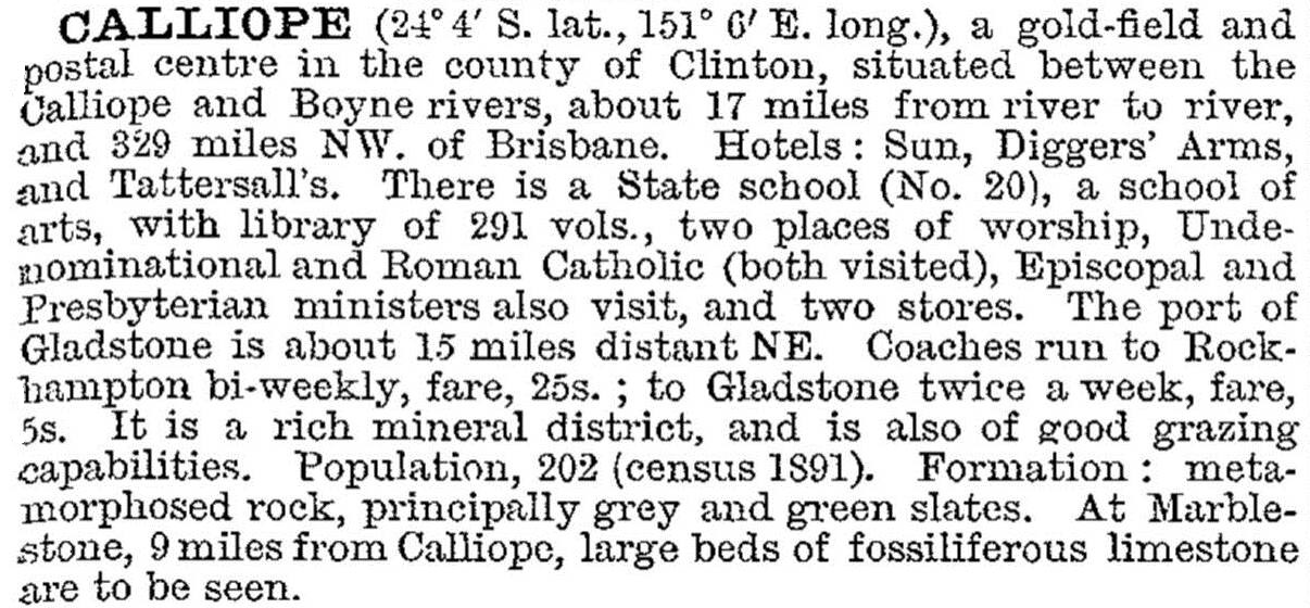
Calliope was described in the 1903 Australian handbook:
In 1968 a second railway line was constructed through Calliope, connecting the Moura coalfield to Gladstone. That event coincided with plans for an alumina refinery in Gladstone, and there was a considerable spill over of population to out-of-town Calliope during the 1970s. In 1975 the shire built new offices beyond Calliope township at Hazelbrook estate, and Calliope's population surpassed 1000 during the early 1990s.
Calliope has a local shopping centre, two hotels, the state primary school (1872), golf, bowling and swimming facilities, a jockey club hosting four meetings a year, a historical village and a tourism information centre.
Council reported that Calliope was undergoing a land boom in 2007, which it attributed to its country location, land affordability and availability of bulk land titles. An accommodation village on 50 hectares was approved in Calliope in 2010 with around 300 units catering for Gladstone's expanding fly-in, fly-out mining workforce. A larger camp proposing to accommodate nearly 3000 workers was rejected by council. In 2013 the State government attempted to sell Calliope land earmarked for a future high school despite community protest.
Its census population have been:
| Census Date | Population |
|---|---|
| 1881 | 59 |
| 1901 | 302 |
| 1911 | 516 |
| 1966 | 442 |
| 1978 | 492 |
| 1981 | 728 |
| 1991 | 962 |
| 2001 | 1182 |
| 2006 | 1550 |
| 2011 | 4206 |
Calliope Shire Council centenary 1879-1979, Calliope, Calliope Shire Council, 1979
