Pialba, a seaside town 32 km north-west of Maryborough, is part of the coastal urban area of Hervey Bay extending from Point Vernon to Urangan. It was the first settled area in the Hervey Bay district and is the commercial and retail centre. Originally named Polson, the town was formally renamed Pialba in 1931. The word, Aboriginal in origin, has several possible meanings.
In 1866 a timber getter, Boyle Martin, settled near the present day Hervey Bay Hotel in Pialba. Before then, since the mid 1850s, the sole European occupiers had been pastoral leaseholders. Martin was joined by other timber-getters who rafted logs up the Mary River to a sawmill, after dragging them by bullock to Urangan. In the 1870s a rudimentary village with a hotel and stores was established, and Maryborough residents took up land allotments along the foreshore for holiday homes. Pialba became their coastal watering place, which had accelerated development when a railway was opened in 1896.
It was not only Maryborough interests which promoted Pialba, as Scandinavian (mainly Danish) immigrants settled the inland scrubs as early as 1871. A Lutheran church was opened in about 1875 in the Nikenbah area, the forerunner of a church and Lutheran school in Pialba. In Pialba itself, a government school and a nondenominational church were opened in 1884 and 1888. Many of the inhabitants were struggling sugar cane growers who in 1883 were endowed with a two local mills. Both failed for want of capital and low returns. Pialba growers were better positioned when the railway took their cane to the Maryborough central mill (1896).
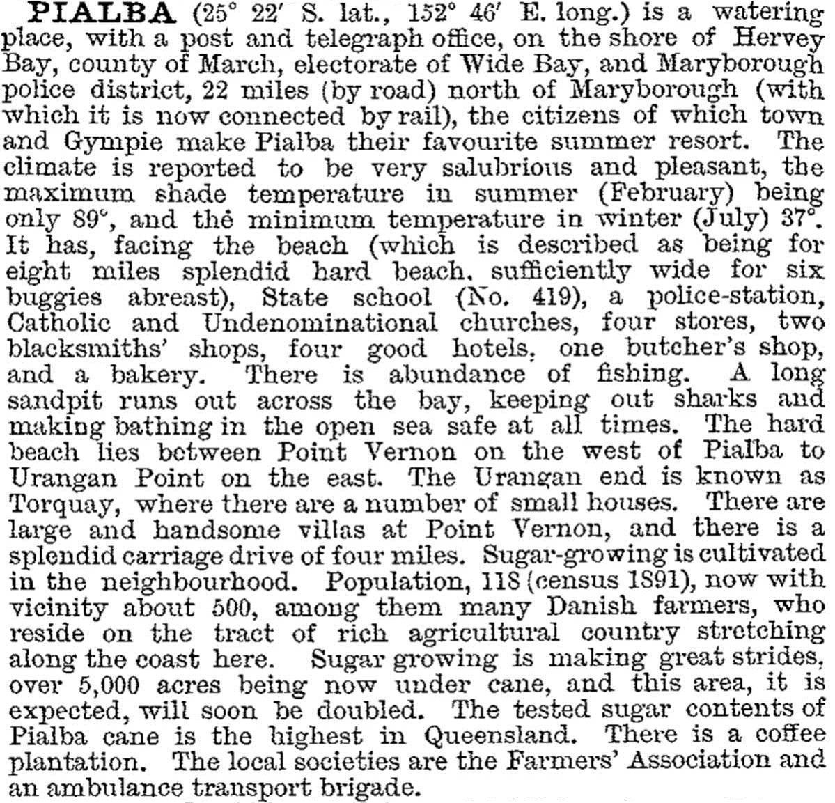
Pialba was part of the Burrum local government division (1880), which in 1905 was reduced in size and named Pialba Shire. A shire hall was built in Pialba. The town was described at length, with mentions of Point Vernon and Urangan, in the Australian handbook in 1903:
Pialba Shire was amalgamated with parts of four others in 1917 to create a new Burrum Shire, entirely surrounding Maryborough. The Pialba township became the coastal area's commercial centre, surrounded by a mixed farming area which included tropical fruits, citrus, sugar and dairying. Offshore there were well stocked fish and shellfish areas, maintaining a local fleet and drawing recreational anglers. Holiday makers had a choice of rail or bus services, and popular annual railway picnics until World War I.
In 1954 the Point Vernon-Pialba-Urangan area had a population of 3500, and by 1994 it was about 30,000, inhabiting a coastal stretch referred to as Hervey Bay. Drive-in shopping areas were opened, Bay Plaza (1982) and a short distance away, Pialba Place (1987). The largest, out of the traditional shopping centres, is Bay Central (1995). The main anchor tenants are supermarkets or a discount department store.
The Hervey Bay Hospital (1963), a TAFE/Senior College, the Hervey Bay high school (1964) and a campus of the University of Southern Queensland are in Pialba or the neighbouring locality of Urraween. Hervey Bay's recreational attractions are mostly in Torquay and Urangan, but Pialba has a golf/country club and a bowling club. In 2005 the Hervey Bay council approved a plan for medium-rise building along Main Street, and the transfer of its offices from Torquay to Pialba. The plan also included Improved road access from the southern suburbs. Pialba's census populations have been:
| Census Date | Population |
|---|---|
| 1891 | 118 |
| 1933 | 459 |
| 2006 | 3164 |
| 2011 | 3528 |
Frances Chan, Hervey Bay and the Fraser Coast, Rockhampton, Central Queensland University Press, 1999
Joan Christiansen, They came ... and stayed: a history of Hervey Bay, Pialba, R. & J. McTaggart, 1991
George Loyau, The History of Maryborough... 1850-1895, Modbury, S. Aust: Archive CD Books Australia, c2005


