Rosewood, a rural town on the Toowoomba railway line, is 17 km west of Ipswich. It is thought that it was named after a Rosewood tree or shrub, a common name for various species, but probably Dysoxylum or Acacia harpophylla, both endemic to south-east Queensland. Other possibilities exist, as the Rosewood scrub extended from Rosewood to Fernvale, 20 km northwards.
The Rosewood scrub included numerous valuable timbers. Some were sensibly harvested but others were cleared for farming. Initially productive, some scrub soils unexpectedly lost fertility, but by the 1880s both sawmilling and mixed farming constituted the main activity of the Rosewood Scrub community. Rosewood was on the Ipswich to Grandchester railway line (1865), and in 1877 an exploratory shaft was sunk at Rosewood in the hope of finding coal for the locomotives. Coal mining was active east of Rosewood, towards Walloon, until 1903 when a new colliery was opened two kilometres east of Rosewood. Rosewood Collieries Ltd (1904) was just 200 metres from the railway station, but it petered out. Better deposits were later found to the north.
The Rosewood settlement was identified by a school and a Congregational church (both 1875) a block away from the railway line, but its civic significance probably began with the erection of a courthouse and police station in 1892. Both are listed on the Queensland heritage register. During the first decade of the 1900s the town gained several of its important buildings and became the administrative centre of the Rosewood Shire (1905): the Rising Sun hotel, with an unusual corner turret (1909), St Brigid's church (1910) and the commencement of Thomas Bulcock's 'Glendalough' residence just north of the town. The last two are on the Australian heritage register, St Brigid's being a significant large-scale timber-framed church with a pressed metal and fretwork interior. Glendalough is recorded as a notable example of an opulent Queensland house, a landmark on its hillside location. The police and court-house complex (1908) in John Street are listed on the Queensland heritage register.
In 1911, a branch railway, winding northwards past several coal mines to Marburg, was opened. Passenger traffic declined within a decade, not least because of the frequent stopping and starting for freight - calves, pigs, dairy produce and coal. The line was closed in stages between 1964 and 1979.
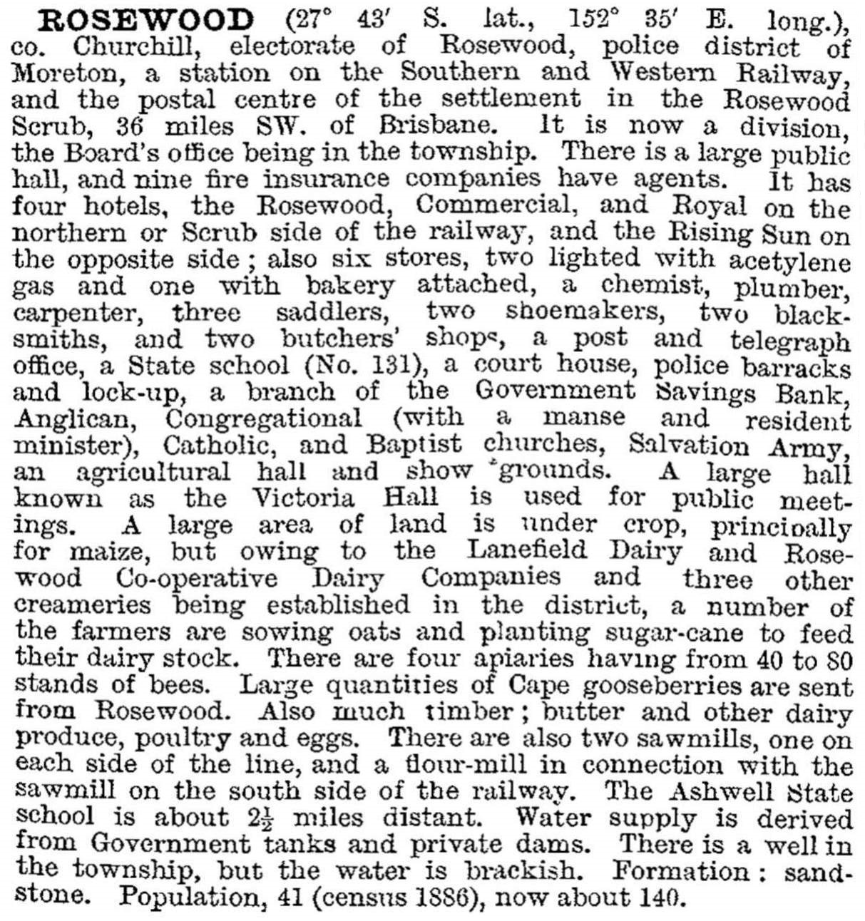
In the midst of its decade of greatest growth Rosewood was described in 1903 in the Australian handbook:
In 1925 the Queensland film producer, Charles Chauvel, made The Moth of Moonbi (adapted from the popular Queensland novel by Mabel Forrest) at various locations at Franklin Vale and in the Rosevale Valley, 25 km south-west of Rosewood.
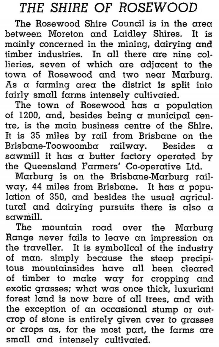
The Rosewood Shire extended up the Marburg valley. The railway line passed nine working coal mines in the 1940s, as well as dairy farms and timber cutting on the distant ranges. Rosewood had both a sawmill and the Queensland Farmers Co-operative butter factory. According to the Australian Blue Book (1946):
The productive vision became less appealing as the valley's Black Snake Creek became saltier, and the loss of the scrub was noticed. The Rosewood Scrub Peace Park is an attempt to recover a sample of the species-rich vegetation.
During the 1960s and 1970s there was a loss of population as dairying and mining contracted, although the Oakleigh colliery continued. Rosewood's population recovered, as its commuting distance to Ipswich was convenient, and an electric train service began in 1993. The steam train has not been entirely obliterated, as a steam railway and museum operate on the old line at Kunkala, a station 3 km out of Rosewood.
Rosewood township has a good range of facilities, besides its rural townscape: local shops, three hotels, State high (1980) and primary schools, a Catholic primary School (1922), a showground, bowling, golf and swimming venues, and an aged persons' centre. In addition to the heritage-registered St Brigid's Catholic church (1909), there are Anglican, Baptist, Lutheran and Uniting churches. There are a community centre, a farmers' hall and a CWA Hall. Rosewood's census populations have been:
| area | Census Date | Population |
|---|---|---|
| Rosewood township | 1881 | 9 |
| 1901 | 357 | |
| 1911 | 1418 | |
| 1954 | 1582 | |
| 1976 | 1702 | |
| 1991 | 1656 | |
| 2001 | 2023 | |
| 2006 | 1966 | |
| 2011 | 2746 | |
| Rosewood Shire | 1911 | 3195 |
| 1921 | 4321 | |
| 1947 | 4249 |
Rosewood Shire was incorporated into Moreton Shire in 1949.
R.L. Whitmore, Coal in Queensland: from federation to the twenties, St Lucia, University of Queensland Press, 1991


