Seventeen Mile Rocks, a rural and industrial place until the mid-1970s, is a residential suburb on the Brisbane River. Opposite Fig Tree Pocket, it is 17 nautical miles and 11 km in a straight line from central Brisbane. It is the chronological last of the 'centenary suburbs', south-west of Brisbane.
The rocks in the Brisbane River formed a blockage to boats and in 1862 they were partly removed. The river in that area is known as Mermaid Reach, and was regarded as one of the finest stretches. The adjoining land was good for timber and farming, and much of it was acquired by the Sinnamon family and farmed for over a century. Their first farmhouse (1869) in Seventeen Mile Rocks Road survives, as does a former Methodist church (1888), now the Rocks Uniting Church. The Sinnamon family constructed a bark and shingle church in 1880. Their homestead Glen Ross (1887) burnt down in July 2007.
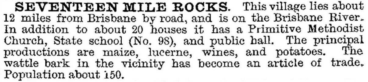
Seventeen Mile Rocks was described in the 1903 Australian handbook:
In 1959 land subdivisions began for the Centenary suburbs of Jindalee, Jamboree Heights etc. Hercules Sinnamon, a landowner east of the Centenary Highway held out, wanting to keep his land rural, largely succeeding until the 1980s. The Jindalee primary school took children away from the Rocks school (1868) which closed in 1966. The most significant development was the Sinnamon Retirement Village (1977), a Methodist project just east of the Centenary Highway. Jennings and Hooker residential estates followed in the 1980s, the former being named Sinnamon Park. A Sinnamon Park Progress Association was formed and lobbied for the creation of a new suburb: Sinnamon Park was detached from Seventeen Mile Rocks in 1989.
The river shoreline had been turned over to industrial uses, a notable example being Queensland Cement Ltd in Sinnamon Park. In Seventeen Mile Rocks a local action group agitated for parklands in 1989, including the site of the defunct Western Drive-In theatre. The drive-in site at Molesworth and Argyle Streets came under housing, but riverside land was reserved. In 2003 the Brisbane City Council completed its 26 ha Riverside Park.
During 1991-2001 the population of Seventeen Mile Rocks and Sinnamon Park grew by 145% to 6725. Most of the growth was in Seventeen Mile Rocks. The Edenbrook Drive estate, in both suburbs, was a sought-after area in 2001, with nearly a quarter of the area being reserved as bushland open space.
Seventeen Mile Rocks is houses and parklands. Shopping and schools are in Sinnamon Park, Jindalee, Darra and Mount Ommaney.
FLOODS 2011
The Rocks Riverside Park was flooded in January 2011 along with a built-up area to its west. The linear park and wetland south of Oldfield Road was also flooded.
The census populations of Seventeen Mile Rocks and Sinnamon Park have been:
| Census Date | Population | |
|---|---|---|
| Seventeen Mile Rocks and Sinnamon Park |
1911 | 85 |
| 1966 | 71 | |
| 1976 | 295 | |
| 1981 | 1089 | |
| 1991 | 2736 | |
| 1996 | 4356 | |
| 2001 | 6725 | |
| Seventeen Mile Rocks | 2006 | 2899 |
| 2011 | 2970 |
H.V Sinnamon, The gentleman farmer's paradise: a story of pioneering last century in Jindalee, other Centenary suburbs, 17 Mile Rocks and Oxley by several families including the Sinnamon, 17 Mile Rocks, H.V. Sinnamon, 1980
Meg Gordon and Lynda Young, Pastoralists of Brisbane town's fringe: pioneers of Seventeen Mile Rocks and Wolston, Brisbane, Centenary Suburbs Historical Society, 2010
Meg Gordon, Thomas Boyland, an adaptive man: pioneer steamboat proprietor, coal miner, pastoralist, Centenary Suburbs Historical Society, 2008
Meg Gordon, When river was roadway: pioneer farmers of Brisbane’s Seventeen Mile Rocks district, Centenary Suburbs Historical Society, 2011
Sinnamon Park entry

